Forecasting Urban Growth

Research Summary

We apply our models of urban change to different policy and socioeconomic scenarios to forecast future urban growth.

Some forecasts explore different future scenarios of GDP, rent, wages, demographics, policy, and investment.  Other methods match probabilistic estimates of growth to spatially explicit grid-based models, which use features of topography, population density, and existing infrastructure as primary drivers of land change (Seto et al., 2012). All forecasts rely on consistent satellite measurements of current urban coverage, which facilitates aggregation of data across the universe of cities (Seto & Christensen, 2013).

Recent Findings

In 2008, the global urban population exceeded the rural population for the first time, and it is estimated that by 2050, 70% of the world population will live in urban areas (UN DESA, 2012).  Furthermore, mid-range forecasts show an increase of around 1.5 million square kilometers of new urban land area by 2030, an area nearly equal to the land area of Mongolia, and nearly tripling the global urban land area in 2000 (Seto et al. 2011; Seto et al. 2012) These forecasts suggest an important—and limited—window of opportunity to shape future urbanization.

Global Forecast of Urban Expansion Probabilities

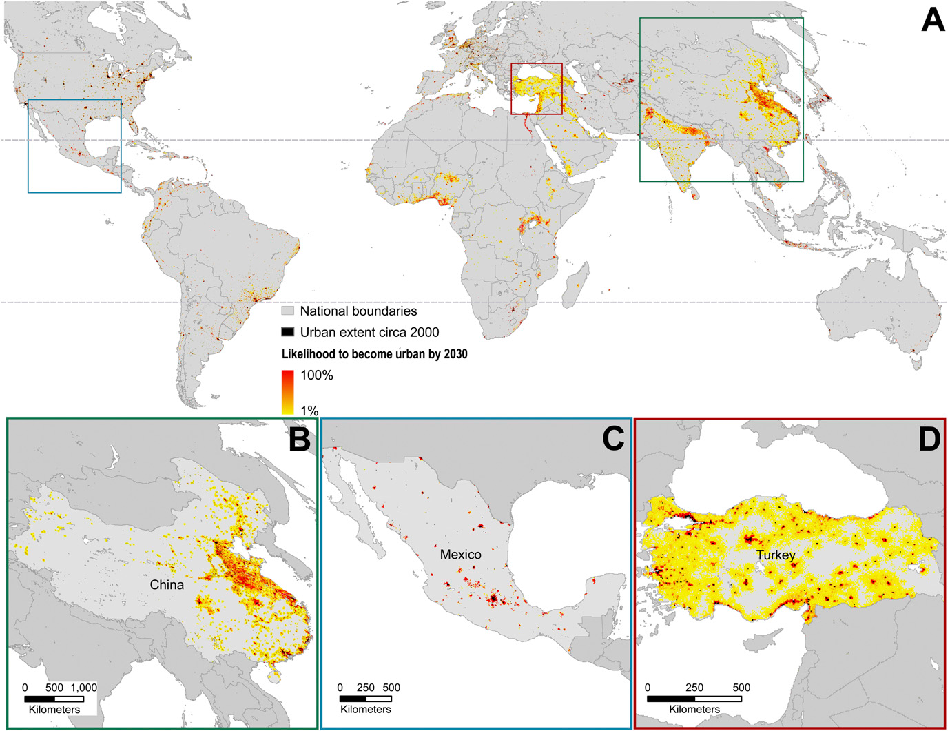
From Seto et al. 2012: Global forecasts of probabilities of urban expansion, 2030. There is significant variation in the amount and likelihood of urban expansion (A). Much of the forecasted urban expansion is likely to occur in eastern China (B). Some regions have high probability of urban expansion is specific locations (C) and others have large areas of low probability urban growth (D). Dashed lines denote northern and southern boundaries of the tropics.

Related Publications

Güneralp B, Zhou Y, Ürge-Vorsatz D, Gupta M, Yu S, Patel PL, Fragkias M, Li X, Seto KC.  2017.  Global scenarios of urban density and its impacts on building energy use through 2050. Proceedings of the National Academy of Sciences. 114(34):8945-8950.
Seto KC, Golden JS, Alberti M, Turner B.L.  2017.  Sustainability in an urbanizing planet. Proceedings of the National Academy of Sciences. 114(34):8935-8938.
Güneralp B, Seto KC.  2013.  Futures of global urban expansion: uncertainties and implications for biodiversity conservation. Environmental Research Letters. 8(1):014025.

Urbanization will place significant pressures on biodiversity across the world. However, there are large uncertainties in the amount and location of future urbanization, particularly urban land expansion. Here, we present a global analysis of urban extent circa 2000 and probabilistic forecasts of urban expansion for 2030 near protected areas and in biodiversity hotspots. We estimate that the amount of urban land within 50 km of all protected area boundaries will increase from 450 000 km2 circa2000 to 1440 000 ± 65 000 km2 in 2030. Our analysis shows that protected areas around the world will experience significant increases in urban land within 50 km of their boundaries. China will experience the largest increase in urban land near protected areas with 304 000 ± 33 000 km2 of new urban land to be developed within 50 km of protected area boundaries. The largest urban expansion in biodiversity hotspots, over 100 000 ± 25 000 km2, is forecasted to occur in South America. Uncertainties in the forecasts of the amount and location of urban land expansion reflect uncertainties in their underlying drivers including urban population and economic growth. The forecasts point to the need to reconcile urban development and biodiversity conservation strategies.

Seto KC, Güneralp B, Hutyra LR.  2012.  Global forecasts of urban expansion to 2030 and direct impacts on biodiversity and carbon pools. Proceedings of the National Academy of Sciences of the United States of America.

Urban land-cover change threatens biodiversity and affects ecosystem productivity through loss of habitat, biomass, and carbon storage. However, despite projections that world urban populations will increase to nearly 5 billion by 2030, little is known about future locations, magnitudes, and rates of urban expansion. Here we develop spatially explicit probabilistic forecasts of global urban land-cover change and explore the direct impacts on biodiversity hotspots and tropical carbon biomass. If current trends in population density continue and all areas with high probabilities of urban expansion undergo change, then by 2030, urban land cover will increase by 1.2 million km2, nearly tripling the global urban land area circa 2000. This increase would result in considerable loss of habitats in key biodiversity hotspots, with the highest rates of forecasted urban growth to take place in regions that were relatively undisturbed by urban development in 2000: the Eastern Afromontane, the Guinean Forests of West Africa, and the Western Ghats and Sri Lanka hotspots. Within the pan-tropics, loss in vegetation biomass from areas with high probability of urban expansion is estimated to be 1.38 PgC (0.05 PgC yr−1), equal to ∼5% of emissions from tropical deforestation and land-use change. Although urbanization is often considered a local issue, the aggregate global impacts of projected urban expansion will require significant policy changes to affect future growth trajectories to minimize global biodiversity and vegetation carbon losses.

Güneralp B, Reilly MK, Seto KC.  2012.  Capturing multiscalar feedbacks in urban land change: a coupled system dynamics spatial logistic approach. Environment and Planning B. 39(5):858-879.

In this paper we ask two questions: Does a multiscalar urban land-change model that couples a region-scale system dynamics model with a local-scale spatial logit model better predict the amount of urban land change than either model alone? Does a multiscalar urban land-change model that couples regional and local-scale factors better predict the spatial patterns of urban land change than a standalone local-scale spatial logit model? To examine these questions, we develop a coupled system dynamics spatial logit (CSDSL) model for the Pearl River Delta, China, that incorporates region-scale population and economic factors with local-scale biophysical and accessibility factors. In terms of predicting the amounts of urban land change, the CSDSL model is 15% and 18% more accurate than the standalone spatial logit and system dynamics models, respectively. In terms of predicting the spatial pattern of urban land change, the CSDSL model slightly outperforms the spatial logit model as measured by four spatial pattern metrics: number of urban patches, urban edge density, average urban patch size, and spatial irregularity of the urban area. Both the CSDSL and spatial logit models underpredict the number of discrete urban patches (by 64% and 80%, respectively) and the urban edge density (by 42% and 62%, respectively). While both models overpredict the average urban patch size, the spatial logit model overpredicts by over 316%, while the CSDSL overpredicts by 192%. Finally, the models perform equally well in predicting the spatial irregularity of urban areas and the location of urban change. Taken together, these results demonstrate that the CSDSL model outperforms a standalone spatial logit or system dynamics model in predicting the amount and spatial complexity of urban land change. The results also show that predicting urban land-change patterns remains more difficult than predicting total amounts of change.

Seto KC.  2011.  Exploring the dynamics of migration to mega-delta cities in Asia and Africa: Contemporary drivers and future scenarios. Global Environmental Change. 21(S1):S94-S107.

This paper uses a content analysis of the published literature to take stock of current understanding of key social and policy drivers of migration to cities in 11 Asian and African mega-deltas and identifies commonalities and differences among them. The analysis shows that migration to urban centers in mega-deltas is an outcome of many forces: economic policies and incentives, local and destination institutions, government policies to develop small towns, and the geographic concentration of investments. Massive influx of capital to many deltas has transformed the local economic base from a primarily agricultural one to a manufacturing and processing economy. This has created uneven spatial economic development which is the underlying driver of migration to cities in the mega-deltas regardless of geographic context or size. Going forward to 2060, one critical challenge for all the deltas is to increase the labor skill of their workforce and foster technology innovation. Continued economic growth in these regions will require substantial investments in education and capacity building and the ability of urban centers to absorb the migrant labor pool.

Global Environmental Change 21(S1): S94-S107
Seto KC, Fragkias M, Güneralp B, Reilly MK.  2011.  A meta-analysis of global urban land expansion. PLOS ONE. 6:e23777.

The conversion of Earth’s land surface to urban uses is one of the most irreversible human impacts on the global biosphere. It drives the loss of farmland, affects local climate, fragments habitats, and threatens biodiversity. Here we present a meta-analysis of 326 studies that have used remotely sensed images to map urban land conversion. We report a worldwide observed increase in urban land area of 58,000 km2 from 1970 to 2000. India, China, and Africa have experienced the highest rates of urban land expansion, and the largest change in total urban extent has occurred in North America. Across all regions and for all three decades, urban land expansion rates are higher than or equal to urban population growth rates, suggesting that urban growth is becoming more expansive than compact. Annual growth in GDP per capita drives approximately half of the observed urban land expansion in China but only moderately affects urban expansion in India and Africa, where urban land expansion is driven more by urban population growth. In high income countries, rates of urban land expansion are slower and increasingly related to GDP growth. However, in North America, population growth contributes more to urban expansion than it does in Europe. Much of the observed variation in urban expansion was not captured by either population, GDP, or other variables in the model. This suggests that contemporary urban expansion is related to a variety of factors difficult to observe comprehensively at the global level, including international capital flows, the informal economy, land use policy, and generalized transport costs. Using the results from the global model, we develop forecasts for new urban land cover using SRES Scenarios. Our results show that by 2030, global urban land cover will increase between 430,000 km2 and 12,568,000 km2, with an estimate of 1,527,000 km2 more likely.

PLOS ONE 6: e23777
Liu W, Seto KC.  2008.  Using the ART-MMAP neural network to predict urban growth: a spatio-temporal data mining approach. Environment and Planning B. 35(2):296-317.

Predicting patterns of urban growth will be a major challenge for policy makers and environmental scientists in the 21st century. How cities grow—their shape and size—will have enormous implications for environmental sustainability and infrastructure needs. This paper presents a spatiotemporal ART-MMAP neural method to simulate and predict urban growth. Factors that affect urban growth—that is, transportation routes, land use, and topography—were directly used as inputs to the neural network model for model calibration. The calibrated network was then applied to a study site—St Louis, Missouri—to predict future urban growth and to examine future land development scenarios. This paper also introduces an effective and straightforward method for model validation and accuracy assessment, the prediction error matrix, which has been used in the pattern recognition field for several decades. In order to assess the performance of the neural network model, an in-depth accuracy assessment was conducted in which the model results were compared against a null model, an alternative naïve model, and two random models. The neural network model consistently outperformed the naïve model and two random models, and produced similar or better results than the null model. Furthermore, we evaluated the models’ performance at different spatial resolutions. The prediction accuracy increases when spatial resolution becomes coarser. One particularly interesting result is that when the results are aggregated to 1 km spatial resolution, there is 100% accuracy of urban growth predicted by the neural network model versus actual urban growth.

Fragkias M, Seto KC, Aspinall RJ, Hill MJ.  2007.  Urban Land Use Change Models, Uncertainty, and Policymaking in Rapidly Growing Developing World Cities. Land Use Change: Science, Policy and Management . :139-160.
Fragkias M, Seto KC.  2007.  Modeling urban growth in data-sparse environments: A new approach. Environment and Planning B. 34(5):858-883.

Although there exist numerous urban growth models, most have significant data input requirements, limiting their utility in a developing-world context. Yet, it is precisely in the developing world where there is an urgent need for urban growth models and scenarios since most expected urban growth in the next two decades will occur in such countries. This paper describes a physical urban growth model that requires few, but widely available, spatially explicit data. Utilizing binary urban/nonurban maps generated by satellite imaging, our model can inform urban planners and policy makers about the most probable locations and periods of future urban land-use change. Using a discrete choice framework, the model employs a spatially explicit logistic regression analysis to evaluate probabilities of urban growth for a baseline period. It calibrates parameters, validates results, predicts urban land-use change and examines future growth scenarios. Future growth scenarios can be generated through the inclusion of land prohibited from development, transportation routes, or new planned urban developments. A novel and important element of the model is the incorporation of an explicit policy-making framework that captures and reduces model uncertainty (theory and specification uncertainties), effectively addressing problems of predictive bias; this framework also allows the user or policy maker to associate predictions with a loss function. The model is applied to three cities in southern China that have experienced dramatic urban land growth in the last two decades. From 1988 to 1999, urban land in the region increased by 451.6% or at an annual rate of approximately 16.5%. Results show that the model achieves 73% – 77% accuracy for different cities at 30 m and 60 m resolutions. Aggregating the predictions to the county/administrative district shows that prediction through thresholding underperforms in comparison to the technique of sample enumeration.

Liu W, Seto KC, Sun Z, Tian Y.  2006.  Urban Land Use Prediction Model with Spatiotemporal Data Mining and GIS. Urban Remote Sensing. :165-178.

Data mining methods have been widely and successfully used in many fields in the last decade. And geographic knowledge discovery and spatial data mining also have attracted more attentions recently. This paper presents an ART-MMAP neural network based spatio-temporal data mining method to simulate and predict urban expansion. The spatial matrices derived from different urban related features, i.e. transportation, land use, topography, were directly used as inputs to the neural network model for learning. The trained network was then applied to research region to predict the land use change to urban. The learning and prediction process are automatic and free of intervention. The method has been successfully validated with the urban growth prediction at St. Louis region at Missouri, USA.